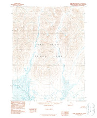
1990 Map of Baird Mountains B-1
USGS Topo · Published 1990About this map
Kobuk Valley National Park dominates this arctic landscape as it was mapped in 1990, shortly after its boundaries were established by the Alaska National Interest Lands Conservation Act. The map captures a transition from high mountain peaks and ridges into a complex low-lying drainage system. The Tutuksuk River winds through the southwestern corner, characterized by numerous marshy wetlands and small ponds that define the river's flood plain. Further east, the Kalliguricheark River cuts through the mountains, providing a major drainage route from the northern heights. This 1990 provisional edition, compiled from late 1970s aerial photography, shows an entirely roadless wilderness where terrain and water systems are the only landmarks for navigation in the Baird Mountains region.
Find a feature on this map
3 named features on this map. Tap any name to fly to it.
Don’t see what you’re looking for? This feature index may not catch every label — zoom into the map to look around manually.
Map Details
Editions of this 1990 Baird Mountains B-1 Map
This is the sole edition of this map. No revisions or reprints were ever made.
Other maps of this area

1951 · Baird Mountains
USGS Topo · 1:250,000

1951 · Ambler River
USGS Topo · 1:250,000

1955 · Baird Mountains A-1
USGS Topo · 1:63,360

1955 · Ambler River A-6
USGS Topo · 1:63,360

1955 · Baird Mountains A-2
USGS Topo · 1:63,360

1956 · Ambler River
USGS Topo · 1:250,000

1956 · Baird Mountains
USGS Topo · 1:250,000

1964 · Ambler River
USGS Topo · 1:250,000

1965 · Baird Mountains
USGS Topo · 1:250,000
1990 · Ambler River B-6
USGS Topo · 1:63,360