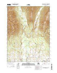
2015 Map of Baird Mountains B-1 SE
USGS Topo · Published 2015About this map
Kobuk Valley National Park encompasses the majority of this landscape, where the Kaliguricheark River winds through the central and northern reaches of the quadrangle. The terrain is defined by dramatic elevation changes, with the contour intervals revealing a series of ridges and valleys that transition from the high peaks in the northwest down toward the river's path. As a 2015 record of this protected wilderness in the Northwest Arctic Borough, the map highlights the intricate drainage patterns of the river and its smaller tributaries. The absence of roads or permanent human settlements underscores the preserved state of this region, providing a detailed topographic study of an area where the Kaliguricheark River remains the primary geographical focal point for navigation and ecological study.
Find a feature on this map
8 named features on this map. Tap any name to fly to it.
Don’t see what you’re looking for? This feature index may not catch every label — zoom into the map to look around manually.
Map Details
Editions of this 2015 Baird Mountains B-1 SE Map
This is the sole edition of this map. No revisions or reprints were ever made.
Other maps of this area

1951 · Baird Mountains
USGS Topo · 1:250,000

1951 · Ambler River
USGS Topo · 1:250,000

1955 · Baird Mountains A-1
USGS Topo · 1:63,360

1955 · Ambler River A-6
USGS Topo · 1:63,360

1956 · Ambler River
USGS Topo · 1:250,000

1956 · Baird Mountains
USGS Topo · 1:250,000

1964 · Ambler River
USGS Topo · 1:250,000

1965 · Baird Mountains
USGS Topo · 1:250,000
1990 · Ambler River B-6
USGS Topo · 1:63,360
1990 · Baird Mountains B-1
USGS Topo · 1:63,360