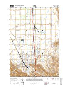
2014 Map of Baker City
USGS Topo · Published 2014About this map
Baker City serves as the focal point of this Eastern Oregon survey, situated within the fertile Baker Valley and framed by the rising slopes of Coyote Peak to the southeast. The landscape is defined by an intricate network of irrigation and drainage features, including the Powder River, Estes Ditch, and Baldock Slough, reflecting the area's agricultural foundation. To the north, Missouri Flat spans a wide plain, while the Baker City Municipal Airport anchors the central valley floor.
Find a feature on this map
104 named features on this map. Tap any name to fly to it.
Don’t see what you’re looking for? This feature index may not catch every label — zoom into the map to look around manually.
Map Details
Editions of this 2014 Baker City Map
This is the sole edition of this map. No revisions or reprints were ever made.
Other maps of this area

1901 · Baker City
USGS Topo · 1:125,000

1955 · Baker
USGS Topo · 1:250,000

1959 · Baker
USGS Topo · 1:250,000

1967 · Virtue Flat
USGS Topo · 1:24,000

1967 · Encina
USGS Topo · 1:24,000

1967 · Baker
USGS Topo · 1:24,000
1967 · Keating NW
USGS Topo · 1:24,000
1967 · Haines
USGS Topo · 1:24,000
1967 · Magpie Peak
USGS Topo · 1:24,000

1967 · Blue Canyon
USGS Topo · 1:24,000