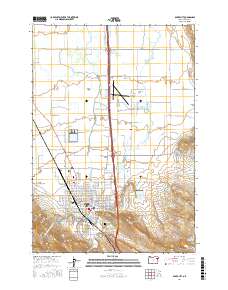
2017 Map of Baker City
USGS Topo · Published 2017About this map
Baker City serves as the focal point of this 2017 survey, where the urban grid meets the agricultural expanse of Baker Valley. The landscape is defined by an intricate network of water management, with the Powder River and Mink Cr supplemented by numerous man-made features like the New Home Ditch, Correll Ditch, and Smith Ditch. These irrigation systems reflect the region's long-standing reliance on controlled water flow for the surrounding valley floor.
Find a feature on this map
114 named features on this map. Tap any name to fly to it.
Don’t see what you’re looking for? This feature index may not catch every label — zoom into the map to look around manually.
Map Details
Editions of this 2017 Baker City Map
This is the sole edition of this map. No revisions or reprints were ever made.
Other maps of this area

1901 · Baker City
USGS Topo · 1:125,000

1955 · Baker
USGS Topo · 1:250,000

1959 · Baker
USGS Topo · 1:250,000

1967 · Virtue Flat
USGS Topo · 1:24,000

1967 · Encina
USGS Topo · 1:24,000

1967 · Baker
USGS Topo · 1:24,000
1967 · Keating NW
USGS Topo · 1:24,000
1967 · Haines
USGS Topo · 1:24,000
1967 · Magpie Peak
USGS Topo · 1:24,000

1967 · Blue Canyon
USGS Topo · 1:24,000