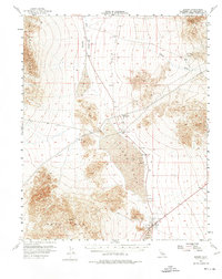
1956 Map of Baker
USGS Topo · Published 1974About this map
Baker stands as a focal point in the high desert of San Bernardino County, situated at the edge of the expansive Soda Lake. This mid-century landscape is defined by the legacy of early transit and extraction, notably the Old Railroad Grade that cuts north through the Silurian Valley toward Riggs. The arid basin is marked by several dry lakebeds, including Silver Lake and Dry Lake, which provided flat surfaces for the development of the Silver Lake Airport. Resource extraction is evident in the foothills of the Silurian Hills, where a Talc mine and a Tunnel are noted. The map captures a moment when traditional infrastructure like the Cemetery and water tanks at Baker coexisted with the infrastructure of the burgeoning desert corridor, including a Substation and multiple landing strips.
Find a feature on this map
26 named features on this map. Tap any name to fly to it.
Don’t see what you’re looking for? This feature index may not catch every label — zoom into the map to look around manually.
Map Details
Editions of this 1956 Baker Map
3 editions found

Other maps of this area

1910 · Ivanpah
USGS Topo · 1:250,000

1912 · Ivanpah
USGS Topo · 1:250,000

1933 · Avawatz Mountains
USGS Topo · 1:250,000

1942 · Ivanpah
USGS Topo · 1:250,000

1947 · Trona
USGS Topo · 1:250,000

1947 · Kingman
USGS Topo · 1:250,000

1948 · Kingman
USGS Topo · 1:250,000

1948 · Red Pass Lake
USGS Topo · 1:62,500

1948 · Trona
USGS Topo · 1:250,000

1948 · Cave Mountain
USGS Topo · 1:62,500