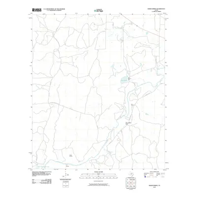
2010 Map of Baker Spring
USGS Topo · Published 2010About this map
The San Saba River defines the central corridor of this ranchland landscape, where water remains the critical factor for life and settlement. In the early 21st century, the area around Sloan and the Sloan Sisters Ranch retains its rural character, anchored by historic family names and essential water sources like Baker Spring and Flemming Spring. The land is dissected by numerous drainages including Turkey Roost Creek, King Creek, and Dry Creek, which flow through various depressions such as Cedar Hollow and T F Hollow. Evidence of long-standing land ownership is seen at the Ellis Cemetery, while more modern water management is represented by Lake Margery and its associated dam. A network of rural roads, including Richland Springs River Rd and S Cotton Belt Rd, connects these remote ranching properties.
Find a feature on this map
28 named features on this map. Tap any name to fly to it.
Don’t see what you’re looking for? This feature index may not catch every label — zoom into the map to look around manually.
Map Details
Editions of this 2010 Baker Spring Map
This is the sole edition of this map. No revisions or reprints were ever made.
Other maps of this area

1885 · San Saba
USGS Topo · 1:125,000

1894 · Brady
USGS Topo · 1:125,000

1894 · San Saba
USGS Topo · 1:125,000

1928 · Mercury
USGS Topo · 1:62,500

1930 · Richland Springs
USGS Topo · 1:62,500

1948 · Richland Springs
USGS Topo · 1:62,500

1950 · Mercury
USGS Topo · 1:62,500
1950 · Richland Springs
USGS Topo · 1:62,500

1954 · Brownwood
USGS Topo · 1:250,000
1955 · Buffalo Knob
USGS Topo · 1:24,000