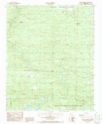
1986 Map of Baker Springs
USGS Topo · Published 1986About this map
Baker Springs and the surrounding woodlands of the Ouachita National Forest define this mid-1980s topographical study of western Arkansas. The landscape is dominated by the winding course of the Cossatot River, which flows southward toward Gillham Lake, a reservoir with its water levels marked at Normal Pool 502. Small settlements like Hartley and Duckett are scattered across the terrain, connected by rural routes that cross numerous drainages including Harris Creek, Baker Creek, and Cow Creek.
Find a feature on this map
23 named features on this map. Tap any name to fly to it.
Don’t see what you’re looking for? This feature index may not catch every label — zoom into the map to look around manually.
Map Details
Editions of this 1986 Baker Springs Map
This is the sole edition of this map. No revisions or reprints were ever made.
Other maps of this area

1913 · De Queen
USGS Topo · 1:125,000

1950 · Mcalester
USGS Topo · 1:250,000

1959 · Umpire
USGS Topo · 1:62,500

1959 · Cove
USGS Topo · 1:62,500

1962 · McAlester
USGS Topo · 1:250,000

1964 · Gillham Dam
USGS Topo · 1:24,000

1964 · Gillham
USGS Topo · 1:24,000

1965 · McAlester
USGS Topo · 1:250,000
1966 · Dierks Dam
USGS Topo · 1:24,000
1984 · Vandervoort
USGS Topo · 1:24,000