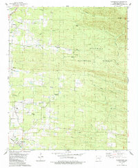
1984 Map of Vandervoort
USGS Topo · Published 1984About this map
Hatfield and Vandervoort anchor this mid-1980s topography of Polk County, where the Kansas City Southern railroad cuts through the western reaches of the Ouachita National Forest. The map reveals a landscape defined by its creek valleys and rural landmarks, featuring numerous local burial grounds including Lone Valley Cemetery, Foote Cemetery, and the Whole Council of God Cemetery. Small-scale industry is evident through scattered Shale Pit extractions, while the geography of the era remains deeply tied to the land's hydrology. Waterways like Barren Creek, Buffalo Creek, and Little Hickory Creek thread through the terrain, with many crossings still marked simply as Ford. From the Union Church to the curiously noted Old Cave, the sheet provides a detailed look at the interface between established settlements and the wooded national forest during this period of the late 20th century.
Find a feature on this map
27 named features on this map. Tap any name to fly to it.
Don’t see what you’re looking for? This feature index may not catch every label — zoom into the map to look around manually.
Map Details
Editions of this 1984 Vandervoort Map
This is the sole edition of this map. No revisions or reprints were ever made.
Other maps of this area

1890 · Poteau Mountain
USGS Topo · 1:125,000

1899 · Poteau Mountain
USGS Topo · 1:125,000

1913 · De Queen
USGS Topo · 1:125,000

1950 · Mcalester
USGS Topo · 1:250,000

1958 · Mena
USGS Topo · 1:62,500

1958 · Potter
USGS Topo · 1:62,500

1958 · Zafra
USGS Topo · 1:24,000

1958 · Mena
USGS Topo · 1:24,000
1958 · Potter
USGS Topo · 1:24,000

1959 · Umpire
USGS Topo · 1:62,500