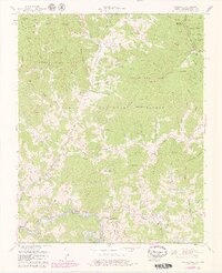
1960 Map of Bakersville
USGS Topo · Published 1979About this map
Bakersville serves as the focal point for this mountain landscape, which is marked by the steep relief of the Pisgah National Forest and Cherokee National Forest. In the late 1970s, the community of Loafers Glory and the small settlement of Buladean remain connected by winding roads through gaps like Pumpkin Patch Gap and Toll House Gap. The Clinchfield RR follows the course of the Toe River along the southern edge, representing the vital transport corridor for this part of Mitchell County. High-elevation landmarks such as Roan High Bluff and Beartown Mountain dominate the topography, while the map records dozens of family-named cemeteries, including the Bakersville Cemetery and Ledford Cemetery, alongside local institutions like Bowman High School and several rural churches including Fork Mountain Church.
Find a feature on this map
114 named features on this map. Tap any name to fly to it.
Don’t see what you’re looking for? This feature index may not catch every label — zoom into the map to look around manually.
Map Details
Editions of this 1960 Bakersville Map
3 editions found
Other maps of this area

1891 · Roan Mountain
USGS Topo · 1:125,000

1894 · Roan Mountain
USGS Topo · 1:125,000

1900 · Mount Mitchell
USGS Topo · 1:125,000

1902 · Mount Mitchell
USGS Topo · 1:125,000

1904 · Roan Mountain
USGS Topo · 1:125,000

1934 · Micaville
USGS Topo · 1:24,000

1934 · Spruce Pine
USGS Topo · 1:24,000

1934 · White Rocks Mtn
USGS Topo · 1:24,000

1934 · Bakersville
USGS Topo · 1:24,000

1934 · Iron Mtn Gap
USGS Topo · 1:24,000