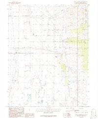
1986 Map of Baking Powder Flat
USGS Topo · Published 1987About this map
Baking Powder Flat dominates this high-desert basin in White Pine County, showing a landscape defined by scarce water sources and expansive terrain during the mid-1980s. The map highlights the essential role of springs and wells in this arid environment, featuring North Spring, Doyles Well, and the seasonal moisture of The Seep. Near the western edge of the Humboldt National Forest, the vegetation transitions at The Cedars, while active geological processes are evident in the Sand Dunes that shift across the flat. Local human presence is sparse but concentrated at Scottys Meadow, with evidence of infrastructure in the form of a Landing Strip and an Aqueduct. The geography suggests a region primarily used for grazing and resource management, supported by numerous unnamed wells and ditches that crisscross the valley floor.
Find a feature on this map
20 named features on this map. Tap any name to fly to it.
Don’t see what you’re looking for? This feature index may not catch every label — zoom into the map to look around manually.
Map Details
Editions of this 1986 Baking Powder Flat Map
This is the sole edition of this map. No revisions or reprints were ever made.
Other maps of this area

1948 · Wheeler Peak
USGS Topo · 1:62,500

1950 · Wheeler Peak
USGS Topo · 1:62,500

1952 · Ely
USGS Topo · 1:125,000

1956 · Lund
USGS Topo · 1:250,000

1956 · Ely
USGS Topo · 1:250,000

1959 · Ely
USGS Topo · 1:250,000

1959 · Sacramento Pass
USGS Topo · 1:62,500

1959 · Connors Pass
USGS Topo · 1:62,500

1960 · Lund
USGS Topo · 1:250,000

1963 · Ely
USGS Topo · 1:250,000