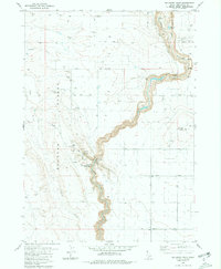
1980 Map of Balanced Rock
USGS Topo · Published 1981About this map
Salmon Falls Creek carves a deep path through the Bruneau Desert in this high-desert region of Twin Falls County. The 1980 landscape is defined by the sharp contrast between the arid plateaus and the developed water infrastructure necessary for local survival and recreation. The Balanced Rock State Park serves as a primary landmark, where the Pumping Sta Balanced Rock Crossing and Picnic Area indicate a managed interface with the steep canyon terrain. Industrial and military footprints are visible through the Buhl National Guard Rifle Range and several gravel and borrow pits. Water management is further evidenced by the Magic Water Canal and the presence of Bluegill Lake, highlighting how the natural drainage of Deadman Creek and Blue Gulch has been augmented by human engineering to support the area's utility.
Find a feature on this map
22 named features on this map. Tap any name to fly to it.
Don’t see what you’re looking for? This feature index may not catch every label — zoom into the map to look around manually.
Map Details
Editions of this 1980 Balanced Rock Map
2 editions found
Other maps of this area

1949 · Thousand Springs
USGS Topo · 1:24,000

1951 · Thousand Springs
USGS Topo · 1:24,000

1954 · Thousand Springs
USGS Topo · 1:24,000

1955 · Twin Falls
USGS Topo · 1:250,000

1958 · Twin Falls
USGS Topo · 1:250,000

1958 · Buhl
USGS Topo · 1:24,000

1959 · Buhl
USGS Topo · 1:62,500

1959 · Crows Nest
USGS Topo · 1:62,500

1965 · Roseworth NE
USGS Topo · 1:24,000

1965 · Tuanna Butte
USGS Topo · 1:24,000