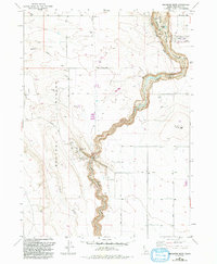
1980 Map of Balanced Rock
USGS Topo · Published 1992About this map
Salmon Falls Creek carves a deep, winding canyon through this portion of the Bruneau Desert, creating a sharp contrast between the arid plateau and the riparian corridor. The most distinctive landmark is Balanced Rock, located within the Balanced Rock County Park, where a Picnic Area and Pumping Sta serve as focal points for the local geography. The landscape is defined by its drainage systems, including Deadman Creek and Blue Gulch, which feed into the main canyon.
Find a feature on this map
29 named features on this map. Tap any name to fly to it.
Don’t see what you’re looking for? This feature index may not catch every label — zoom into the map to look around manually.
Map Details
Editions of this 1980 Balanced Rock Map
2 editions found
Other maps of this area

1949 · Thousand Springs
USGS Topo · 1:24,000

1951 · Thousand Springs
USGS Topo · 1:24,000

1954 · Thousand Springs
USGS Topo · 1:24,000

1955 · Twin Falls
USGS Topo · 1:250,000

1958 · Twin Falls
USGS Topo · 1:250,000

1958 · Buhl
USGS Topo · 1:24,000

1959 · Buhl
USGS Topo · 1:62,500

1959 · Crows Nest
USGS Topo · 1:62,500

1965 · Roseworth NE
USGS Topo · 1:24,000

1965 · Tuanna Butte
USGS Topo · 1:24,000