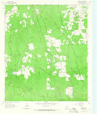
1963 Map of Bald Hill
USGS Topo · Published 1966About this map
Bald Hill rises above the piney woods of Angelina County, anchoring a landscape defined by small rural settlements and a mid-century energy infrastructure. During the early 1960s, the area around Prairie Grove and Shady Grove maintained a traditional East Texas character, with Pine Grove Ch and Gilbert Chapel serving as local community hubs. This era also shows the shifting economic focus of the region, where the timber and rail era of the Old Railroad Grade is overlaid by modern utility corridors, including a prominent Pipeline network and a Pumping Sta.
Find a feature on this map
21 named features on this map. Tap any name to fly to it.
Don’t see what you’re looking for? This feature index may not catch every label — zoom into the map to look around manually.
Map Details
Editions of this 1963 Bald Hill Map
2 editions found
Other maps of this area

1927 · Lufkin 4-c
USGS Topo · 1:24,000

1928 · Lufkin 4-d
USGS Topo · 1:24,000

1932 · Manning
USGS Topo · 1:62,500

1949 · Lufkin
USGS Topo · 1:62,500

1949 · Lufkin
USGS Topo · 1:24,000

1949 · Huntington
USGS Topo · 1:24,000

1949 · Keltys
USGS Topo · 1:24,000

1950 · Keltys
USGS Topo · 1:24,000

1950 · Lufkin
USGS Topo · 1:24,000

1950 · Huntington
USGS Topo · 1:24,000