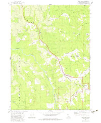
1982 Map of Bald Hills
USGS Topo · Published 1983About this map
Redwood National Park dominates the western portion of this topographic study, where the terrain drops sharply toward the winding course of Redwood Creek. High above the river valley, the namesake Bald Hills form a distinctive series of open grasslands and ridges. This landscape is defined by its numerous named prairies, including Hancorne Prairie, Thompson Prairie, and Bear Prairie, which suggest a long history of upland ranching and grazing.
Find a feature on this map
49 named features on this map. Tap any name to fly to it.
Don’t see what you’re looking for? This feature index may not catch every label — zoom into the map to look around manually.
Map Details
Editions of this 1982 Bald Hills Map
2 editions found
Other maps of this area

1925 · Hoopa
USGS Topo · 1:125,000

1945 · Orick
USGS Topo · 1:62,500

1945 · Trinidad
USGS Topo · 1:62,500

1945 · Coyote Peak
USGS Topo · 1:62,500

1945 · Tectah Creek
USGS Topo · 1:62,500

1948 · Weed
USGS Topo · 1:250,000

1949 · Eureka
USGS Topo · 1:250,000

1950 · Weed
USGS Topo · 1:250,000
1952 · Orick
USGS Topo · 1:62,500

1952 · Coyote Peak
USGS Topo · 1:62,500