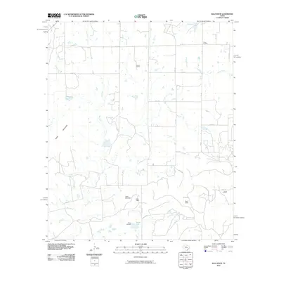
2010 Map of Bald Knob
USGS Topo · Published 2010About this map
Bald Knob and the prominent Moro Mountain define the topography of this Taylor County landscape, where the high mesas of Table Mountain and the natural passage at Table Gap break the surrounding plains. The territory is a mix of ranching land and energy production, anchored by the Atwood Oil Field in the north-central section. Significant water features including Elm Creek and Buffalo Creek drain the area, while the Billups Lake Dam creates a localized reservoir at Billups Lake. For those tracing local family histories, the presence of Dewey Cemetery and Counts Cemetery offers specific points of interest among the network of rural roads like FM 382 and Co RD 175 that connect these dispersed landmarks.
Find a feature on this map
35 named features on this map. Tap any name to fly to it.
Don’t see what you’re looking for? This feature index may not catch every label — zoom into the map to look around manually.
Map Details
Editions of this 2010 Bald Knob Map
This is the sole edition of this map. No revisions or reprints were ever made.
Other maps of this area

1890 · Abilene
USGS Topo · 1:125,000

1892 · Abilene
USGS Topo · 1:125,000

1892 · Ballinger
USGS Topo · 1:125,000

1954 · Brownwood
USGS Topo · 1:250,000

1954 · Abilene
USGS Topo · 1:250,000

1958 · Abilene
USGS Topo · 1:250,000

1967 · Novice West
USGS Topo · 1:24,000

1967 · Tuscola
USGS Topo · 1:24,000
1967 · Lake Abilene
USGS Topo · 1:24,000
1967 · Lawn
USGS Topo · 1:24,000