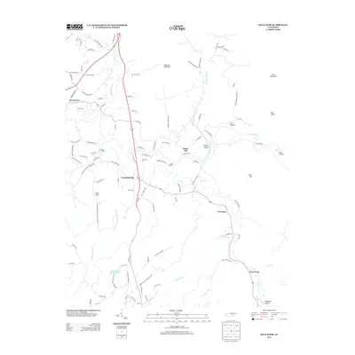
2013 Map of Bald Knob
USGS Topo · Published 2013About this map
The Calfkiller River and Caney Fork wind through this part of Van Buren County, anchoring a landscape defined by small settlements and river crossings. Small communities like Cummingsville and Greenwood are connected by a network of local roads such as Dola Rd and Cotton Rd, while the terrain is marked by prominent elevations including Milksick Mountain, Pine Mountain, and the namesake Bald Knob.
Find a feature on this map
108 named features on this map. Tap any name to fly to it.
Don’t see what you’re looking for? This feature index may not catch every label — zoom into the map to look around manually.
Map Details
Editions of this 2013 Bald Knob Map
This is the sole edition of this map. No revisions or reprints were ever made.
Other maps of this area

1892 · Pikeville
USGS Topo · 1:125,000

1893 · Mc Minnville
USGS Topo · 1:125,000

1895 · Mc Minnville
USGS Topo · 1:125,000

1895 · Pikeville
USGS Topo · 1:125,000

1943 · Cookeville
USGS Topo · 1:100,000

1944 · Cookeville
USGS Topo · 1:100,000

1953 · Chattanooga
USGS Topo · 1:250,000

1954 · De Rossett
USGS Topo · 1:24,000

1954 · Sparta
USGS Topo · 1:24,000
1954 · Lonewood
USGS Topo · 1:24,000