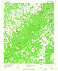
1964 Map of Baldwin
USGS Topo · Published 1965About this map
Baldwin and Alto sit atop the ridge line where the Southern railroad traverses the border of Habersham, Banks, and Hall counties. This mid-1960s landscape is defined by the headwaters of the Hudson River, with numerous small community centers anchored by rural churches such as Mud Creek Church, Liberty Hill Church, and Rock Springs Church. The Presence of the State Industrial Institute near Alto provides a significant institutional landmark amidst the scattered farmsteads and family burial grounds like Mud Creek Cemetery and Jordan Cemetery.
Find a feature on this map
44 named features on this map. Tap any name to fly to it.
Don’t see what you’re looking for? This feature index may not catch every label — zoom into the map to look around manually.
Map Details
Editions of this 1964 Baldwin Map
3 editions found
Other maps of this area

1886 · Dahlonega
USGS Topo · 1:125,000

1886 · Walhalla
USGS Topo · 1:125,000

1891 · Gainesville
USGS Topo · 1:125,000

1891 · Carnesville
USGS Topo · 1:125,000

1892 · Dahlonega
USGS Topo · 1:125,000

1892 · Walhalla
USGS Topo · 1:125,000

1896 · Walhalla
USGS Topo · 1:125,000

1896 · Dahlonega
USGS Topo · 1:125,000

1903 · Dahlonega
USGS Topo · 1:125,000

1954 · Greenville
USGS Topo · 1:250,000