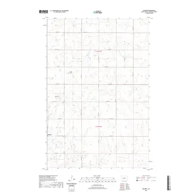
2020 Map of Baldwin
USGS Topo · Published 2020About this map
The settlement of Baldwin serves as the focal point for this section of Burleigh County, characterized by a structured grid of rural section roads and rolling prairie topography. Local history and genealogy are centered at the Baldwin Cem, located just east of the primary township cluster along 201st Ave NE. The landscape is punctuated by Twin Buttes, prominent terrain features that rise above the surrounding plains. Drainage for the region is provided by the winding courses of W Br Apple Cr and Burnt Cr, which cut through the agricultural landscape. Transportation is supported by the small Spitzer Airport to the north, while the Public Land Survey System grid, including boundaries for t142n r79w and t141n r79w, defines the local property and administrative lines that have shaped the development of this North Dakota community.
Find a feature on this map
23 named features on this map. Tap any name to fly to it.
Don’t see what you’re looking for? This feature index may not catch every label — zoom into the map to look around manually.
Map Details
Editions of this 2020 Baldwin Map
This is the sole edition of this map. No revisions or reprints were ever made.
Other maps of this area

1907 · Bismarck
USGS Topo · 1:125,000

1950 · Wilton
USGS Topo · 1:62,500

1951 · Bismarck
USGS Topo · 1:62,500

1951 · Menoken
USGS Topo · 1:62,500

1954 · Bismarck
USGS Topo · 1:250,000

1954 · McClusky
USGS Topo · 1:250,000

1958 · Bismarck
USGS Topo · 1:250,000

1958 · McClusky
USGS Topo · 1:250,000
1962 · Burnt Butte
USGS Topo · 1:24,000

1966 · Wilton SE
USGS Topo · 1:24,000