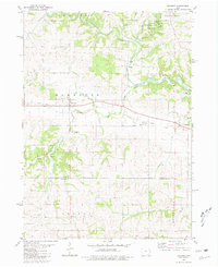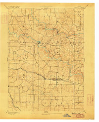
1891 Map of Baldwin
USGS Topo · Published 1906About this map
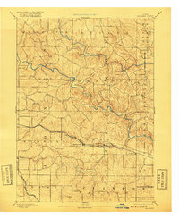
The Maquoketa River and its North Fork carve through the landscape of Eastern Iowa in this late nineteenth-century survey. The terrain is characterized by the convergence of Jackson, Jones, and Clinton counties, where early settlements like Clay Mills and Ozark were established along the water's edge. The Chicago and North Western Railroad serves as a primary east-west artery, connecting the towns of Monmouth and Baldwin. This era captures the region's transition from a water-powered economy, evidenced by names like Clay Mills, to a rail-centered network. Smaller rural centers such as Canton, Emaline, and Nashville appear as clusters of activity within the townships of Brandon and Farmers Creek. The map also documents the Chicago Milwaukee and St. Paul Railroad cutting across the southwestern corner through Wyoming, illustrating the competing rail interests that defined the agricultural landscape of the 1890s.
Find a feature on this map
35 named features on this map. Tap any name to fly to it.
Don’t see what you’re looking for? This feature index may not catch every label — zoom into the map to look around manually.
Map Details
Editions of this 1891 Baldwin Map
3 editions found
Historical Maps of Wyoming Through Time
7 maps found