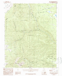
1987 Map of Baldy Mountain
USGS Topo · Published 1987About this map
Philmont Scout Ranch occupies a significant portion of this high-altitude landscape in the Sangre de Cristo Range, where the legacy of early mining and scouting history intersect. The map documents numerous backcountry sites including French Henry Camp, Baldy Camp, and Copper Park Camp, which are scattered around the slopes of Baldy Mountain. This area was once defined by its mineral prospects, evidenced by the Aztec Mine and various unnamed prospects along Aztec Ridge.
Find a feature on this map
34 named features on this map. Tap any name to fly to it.
Don’t see what you’re looking for? This feature index may not catch every label — zoom into the map to look around manually.
Map Details
Editions of this 1987 Baldy Mountain Map
2 editions found
Other maps of this area

1954 · Raton
USGS Topo · 1:250,000

1955 · Ute Park
USGS Topo · 1:62,500

1958 · Raton
USGS Topo · 1:250,000

1962 · Ash Mountain
USGS Topo · 1:62,500

1963 · Eagle Nest
USGS Topo · 1:24,000

1963 · Red River Pass
USGS Topo · 1:24,000

1963 · Comanche Point
USGS Topo · 1:24,000

1982 · Wheeler Peak
USGS Topo · 1:100,000
1986 · Van Bremmer Park
USGS Topo · 1:24,000
1986 · Ash Mountain
USGS Topo · 1:24,000