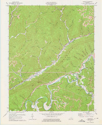
1974 Map of Balkan
USGS Topo · Published 1975About this map
Pine Mountain dominates the landscape in this southeastern Kentucky coal region, carving a dramatic line through Bell County. The valley floors are shaped by the industrial presence of the Louisville and Nashville railroad, which follows the path of Straight Creek and the Cumberland River to serve numerous extraction sites. Numerous strip mines and conveyors are etched into the hillsides, illustrating the intensive resource work around settlements like Balkan and Kettle Island.
Find a feature on this map
91 named features on this map. Tap any name to fly to it.
Don’t see what you’re looking for? This feature index may not catch every label — zoom into the map to look around manually.
Map Details
Editions of this 1974 Balkan Map
This is the sole edition of this map. No revisions or reprints were ever made.
Other maps of this area

1886 · Cumberland Gap
USGS Topo · 1:125,000

1887 · Jonesville
USGS Topo · 1:125,000

1888 · Cumberland Gap
USGS Topo · 1:125,000

1891 · Cumberland Gap
USGS Topo · 1:125,000

1891 · Jonesville
USGS Topo · 1:125,000

1903 · Harlan
USGS Topo · 1:48,000

1903 · Pineville
USGS Topo · 1:48,000

1903 · Middlesboro
USGS Topo · 1:48,000

1916 · Harlan
USGS Topo · 1:48,000

1919 · Harlan
USGS Topo · 1:62,500