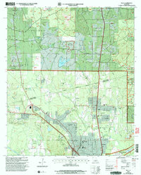
2003 Map of Ball
USGS Topo · Published 2005About this map
Ball and the surrounding piney woods of the Kisatchie National Forest anchor this early 21st-century landscape along the border of Grant and Rapides Parishes. The area is defined by a cluster of suburban and institutional developments, including the sprawling grounds of Camp Beauregard to the southeast and the Pollock Federal Prison further north. Public institutions are a primary feature here, from the State Industrial Sch to various community facilities that mark the growth of the region.
Find a feature on this map
44 named features on this map. Tap any name to fly to it.
Don’t see what you’re looking for? This feature index may not catch every label — zoom into the map to look around manually.
Map Details
Editions of this 2003 Ball Map
This is the sole edition of this map. No revisions or reprints were ever made.
Other maps of this area

1932 · Boyce NE
USGS Topo · 1:31,680

1932 · Colfax SE
USGS Topo · 1:31,680

1936 · Colfax
USGS Topo · 1:62,500

1936 · Pollock
USGS Topo · 1:62,500

1941 · Alexandria
USGS Topo · 1:62,500

1941 · Pollock
USGS Topo · 1:62,500

1941 · Boyce
USGS Topo · 1:62,500

1945 · Boyce SE
USGS Topo · 1:31,680

1949 · Boyce SE
USGS Topo · 1:31,680

1953 · Alexandria
USGS Topo · 1:250,000