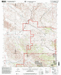
1995 Map of Ballinger Canyon
USGS Topo · Published 2000About this map
The San Andreas Rift Zone slices through this high-desert landscape where the Caliente Range meets the Cuyama Valley. This 1995 revision reveals a complex intersection of land management and historical claims, most notably the Cuyama Grant (Heirs of Cesario Lataillade), which preserves the footprint of a mid-19th-century Mexican land grant. The terrain is marked by the steep descents of Grocer Grade and the wide, arid wash of Ballinger Canyon.
Find a feature on this map
24 named features on this map. Tap any name to fly to it.
Don’t see what you’re looking for? This feature index may not catch every label — zoom into the map to look around manually.
Map Details
Editions of this 1995 Ballinger Canyon Map
This is the sole edition of this map. No revisions or reprints were ever made.
Other maps of this area

1902 · Santa Ynez
USGS Topo · 1:125,000

1903 · Mt. Pinos
USGS Topo · 1:125,000

1905 · Santa Ynez
USGS Topo · 1:125,000

1910 · Buena Vista Lake
USGS Topo · 1:125,000

1912 · McKittrick
USGS Topo · 1:125,000

1912 · Buena Vista Lake
USGS Topo · 1:125,000

1931 · Pentland Junction
USGS Topo · 1:31,680

1934 · Pentland
USGS Topo · 1:31,680

1942 · Ballinger Canyon
USGS Topo · 1:24,000

1942 · East of Cuyama Ranch
USGS Topo · 1:24,000