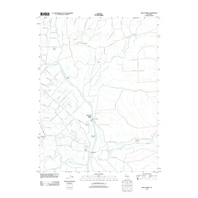
2012 Map of Balls Ferry
USGS Topo · Published 2012About this map
Rancherie Island and Reading Island sit prominently within the braiding currents of the Sacramento River south of Balls Ferry Bridge. This region of Shasta County is defined by its complex riparian networks, where Anderson Cr, Ash Cr, and Battle Cr converge toward the river's main channel. The map highlights a landscape of ranching and early commerce, evidenced by the Fort Reading Ranch and Dersch Ranch, while the Balls Ferry Fishing Resort indicates the area's transition into a destination for river-based recreation. Local heritage is further grounded in the presence of the Parkville Cem and the Coleman Fish Hatchery to the east. Transportation history is noted through the path of Nobles Trail Rd and the Anderson Cottonwood Canal, which cuts through the western terrain near Panorama Point, illustrating the long-standing management of water and transit in this river valley.
Find a feature on this map
76 named features on this map. Tap any name to fly to it.
Don’t see what you’re looking for? This feature index may not catch every label — zoom into the map to look around manually.
Map Details
Editions of this 2012 Balls Ferry Map
This is the sole edition of this map. No revisions or reprints were ever made.
Other maps of this area

1890 · Red Bluff
USGS Topo · 1:250,000

1894 · Red Bluff
USGS Topo · 1:250,000

1901 · Redding
USGS Topo · 1:125,000

1944 · Redding
USGS Topo · 1:62,500

1944 · Tuscan Buttes
USGS Topo · 1:62,500

1946 · Redding
USGS Topo · 1:62,500

1947 · Tuscan Buttes
USGS Topo · 1:62,500

1947 · Anderson
USGS Topo · 1:62,500

1948 · Anderson
USGS Topo · 1:62,500

1953 · Millville
USGS Topo · 1:62,500