
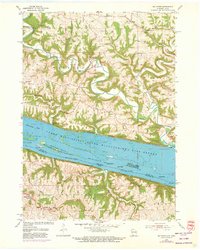
1955 Map of Balltown
USGS Topo · Published 1957About this map
The Upper Mississippi River Wildlife and Fish Refuge dominates the central landscape of this mid-century survey, where the border between Iowa and Wisconsin is defined by the shifting channels and numerous islands of the Upper Mississippi River. Landmarks such as Hurricane Island, Rosebrook Island, and McCartney Lake illustrate the complex riparian environment before modern alterations. Along the riverbanks, the infrastructure of the Chicago Milwaukee St Paul and Pacific and the Chicago Burlington and Quincy railroads highlights the vital transportation corridor connecting regional trade centers.
Find a feature on this map
33 named features on this map. Tap any name to fly to it.
Don’t see what you’re looking for? This feature index may not catch every label — zoom into the map to look around manually.
Map Details
Editions of this 1955 Balltown Map
2 editions found
Other maps of this area

1900 · Lancaster
USGS Topo · 1:125,000

1904 · Lancaster
USGS Topo · 1:125,000

1908 · Lancaster
USGS Topo · 1:125,000

1955 · Cassville
USGS Topo · 1:24,000

1956 · Dubuque North
USGS Topo · 1:24,000

1956 · Sherrill
USGS Topo · 1:24,000

1957 · Holy Cross
USGS Topo · 1:24,000

1957 · Potosi
USGS Topo · 1:24,000

1959 · Dubuque
USGS Topo · 1:250,000

1961 · Dubuque
USGS Topo · 1:250,000