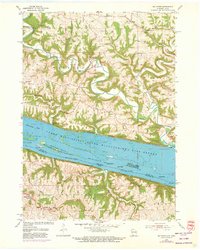
1955 Map of Balltown
USGS Topo · Published 1973About this map
The Mississippi River creates a powerful border between Wisconsin and Iowa in this mid-century survey, defining a landscape of steep coulees and riverine islands. On the Iowa side, the communities of Balltown and Old Balltown sit atop the high ridges of Jefferson township, overlooking the vast Upper Mississippi River Wildlife and Fish Refuge. The lowlands are marked by a complex network of backwaters like McCartney Lake and several named landforms including Hurricane Island and Rosebrook Island.
Find a feature on this map
31 named features on this map. Tap any name to fly to it.
Don’t see what you’re looking for? This feature index may not catch every label — zoom into the map to look around manually.
Map Details
Editions of this 1955 Balltown Map
2 editions found
Other maps of this area

1900 · Lancaster
USGS Topo · 1:125,000

1904 · Lancaster
USGS Topo · 1:125,000

1908 · Lancaster
USGS Topo · 1:125,000

1955 · Cassville
USGS Topo · 1:24,000

1955 · Balltown
USGS Topo · 1:24,000

1956 · Dubuque North
USGS Topo · 1:24,000

1956 · Sherrill
USGS Topo · 1:24,000

1957 · Holy Cross
USGS Topo · 1:24,000

1957 · Potosi
USGS Topo · 1:24,000

1959 · Dubuque
USGS Topo · 1:250,000