
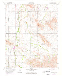
1956 Map of Bally Mountain
USGS Topo · Published 1959About this map
Zodletone Mountain and Bally Mountain anchor the high ground in this mid-century look at the Kiowa County landscape. The area is defined by its rural community centers, particularly Spring Valley Church in the northeast and Saddle Mountain Church to the south. Saddle Mountain Creek winds through the central valley, providing the primary drainage for the surrounding slopes. While the land is largely open, industrial activity is noted with Oil tanks in the southwest, showing the intersection of agriculture and energy extraction during the 1950s. For those tracing family roots, the Green Valley Cemetery provides a specific point of genealogical interest, situated amidst the complex network of minor drainages like Pecan Creek and Longhorn Mountain Creek.
Find a feature on this map
11 named features on this map. Tap any name to fly to it.
Don’t see what you’re looking for? This feature index may not catch every label — zoom into the map to look around manually.
Map Details
Editions of this 1956 Bally Mountain Map
2 editions found
Other maps of this area

1949 · Cooperton
USGS Topo · 1:62,500

1950 · Saddle Mountain
USGS Topo · 1:62,500

1955 · Lawton
USGS Topo · 1:250,000

1955 · Clinton
USGS Topo · 1:250,000

1956 · Saddle Mountain
USGS Topo · 1:24,000

1956 · Cooperton
USGS Topo · 1:24,000

1956 · Alden
USGS Topo · 1:24,000

1956 · Unap Mountain
USGS Topo · 1:24,000

1956 · Meers
USGS Topo · 1:24,000

1956 · Saddle Mountain
USGS Topo · 1:62,500