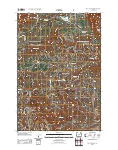
2011 Map of Bally Mountain
USGS Topo · Published 2011About this map
Bally Mountain serves as a central landmark in this portion of the Umatilla National Forest, presiding over a landscape defined by an intricate network of drainages and seasonal water sources. The area is characterized by significant topographical shifts, most notably at The Narrows and within the deep incisions of Cougar Canyon and Bally Canyon. This 2011 survey by the U.S. Geological Survey and U.S. Forest Service documents the vital role of natural springs in this high-country environment, labeling numerous named sources including Wildhorse Spring, McDonald Spring, and Horseshoe Spring. The presence of Bally Camp and a system of forest roads, such as Rocky Ridge Rd and Indian Lake Rd, indicates the area's use for resource management and recreation. To the north, Indian Lake and the headwaters of East Birch Creek provide contrast to the drier, creek-cut ridges that dominate the southern half of the quadrangle.
Find a feature on this map
28 named features on this map. Tap any name to fly to it.
Don’t see what you’re looking for? This feature index may not catch every label — zoom into the map to look around manually.
Map Details
Editions of this 2011 Bally Mountain Map
This is the sole edition of this map. No revisions or reprints were ever made.
Other maps of this area

1953 · Pendleton
USGS Topo · 1:250,000

1956 · Pendleton
USGS Topo · 1:250,000

1963 · Meacham Lake
USGS Topo · 1:24,000

1964 · Mc Intyre Creek
USGS Topo · 1:24,000

1965 · Marley Creek
USGS Topo · 1:24,000
1967 · Bassey Creek
USGS Topo · 1:24,000

1967 · Sullivan Gulch
USGS Topo · 1:24,000

1967 · Lehman Springs
USGS Topo · 1:24,000

1967 · Bally Mountain
USGS Topo · 1:24,000
1967 · Sevenmile Creek
USGS Topo · 1:24,000