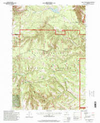
1995 Map of Bally Mountain
USGS Topo · Published 1998About this map
Bally Mountain stands as a central topographic feature in this high-country intersection of the Umatilla National Forest and Wallowa-Whitman National Forest in northeastern Oregon. The landscape is defined by its scientific and historical administrative layers, notably the inclusion of the Starkey Experimental Forest and the path of the Old Indian Reservation Boundary.
Find a feature on this map
33 named features on this map. Tap any name to fly to it.
Don’t see what you’re looking for? This feature index may not catch every label — zoom into the map to look around manually.
Map Details
Editions of this 1995 Bally Mountain Map
This is the sole edition of this map. No revisions or reprints were ever made.
Other maps of this area

1953 · Pendleton
USGS Topo · 1:250,000

1956 · Pendleton
USGS Topo · 1:250,000

1963 · Meacham Lake
USGS Topo · 1:24,000

1964 · Mc Intyre Creek
USGS Topo · 1:24,000

1965 · Marley Creek
USGS Topo · 1:24,000
1967 · Bassey Creek
USGS Topo · 1:24,000

1967 · Sullivan Gulch
USGS Topo · 1:24,000

1967 · Lehman Springs
USGS Topo · 1:24,000

1967 · Bally Mountain
USGS Topo · 1:24,000
1967 · Sevenmile Creek
USGS Topo · 1:24,000