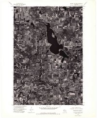
1974 Map of Balsam Lake SW
USGS Topo · Published 1976About this map
Wapogasset Lake dominates the upper half of this orthophotoquad, its irregular shoreline and deep waters providing a central landmark for this portion of Polk County. The landscape is a distinct patchwork of agricultural fields and woodlots, typical of the regional farming patterns in the mid-1970s. The small settlement of Wanderoos is situated in the southwestern portion of the map, appearing as a modest cluster of structures and cross-roads amid the surrounding rural acreage. Produced from aerial photography taken in October 1974, the map provides a high-contrast visual record of the land use and drainage patterns before later development, showing the winding stream beds and smaller ponds that feed into the larger lake system.
Find a feature on this map
2 named features on this map. Tap any name to fly to it.
Don’t see what you’re looking for? This feature index may not catch every label — zoom into the map to look around manually.
Map Details
Editions of this 1974 Balsam Lake SW Map
This is the sole edition of this map. No revisions or reprints were ever made.
Other maps of this area

1900 · St Croix Dalles
USGS Topo · 1:62,500

1901 · St Croix Dalles
USGS Topo · 1:62,500

1948 · New Richmond
USGS Topo · 1:62,500

1949 · New Richmond
USGS Topo · 1:62,500

1950 · Deer Park
USGS Topo · 1:62,500

1950 · Balsam Lake
USGS Topo · 1:62,500

1953 · Stillwater
USGS Topo · 1:250,000

1955 · St. Croix Dalles
USGS Topo · 1:62,500

1955 · Stillwater
USGS Topo · 1:250,000

1958 · Stillwater
USGS Topo · 1:250,000