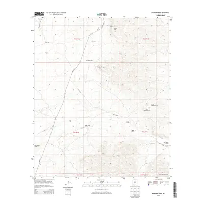
2013 Map of Bandanna Point
USGS Topo · Published 2013About this map
Russell Ranch and Moss Ranch anchor the high desert landscape of Eddy County in this 2013 survey. The terrain is defined by a complex drainage system, featuring deep-cut features such as Last Chance Canyon and Weldy Canyon that carve through the limestone geology of the northern Guadalupe Mountains. The interplay of elevated plateaus like Azotea Mesa and broad depressions like Sotol Basin reveals a landscape dictated by seasonal water flow and ranching life. Transport through this arid region relies on established routes such as Queens Hwy and Dark Canyon Rd, which navigate around prominent landmarks like Bandanna Point. This map provides a look at the modern rural infrastructure of southeastern New Mexico, documenting the remote outposts and geographic naming conventions used by the cattle and land-use interests of the early 21st century.
Find a feature on this map
34 named features on this map. Tap any name to fly to it.
Don’t see what you’re looking for? This feature index may not catch every label — zoom into the map to look around manually.
Map Details
Editions of this 2013 Bandanna Point Map
This is the sole edition of this map. No revisions or reprints were ever made.
Other maps of this area

1940 · Bandanna Point
USGS Topo · 1:62,500

1940 · Carlsbad Caverns West
USGS Topo · 1:62,500

1943 · Carlsbad Caverns West
USGS Topo · 1:62,500

1943 · Bandanna Point
USGS Topo · 1:62,500

1943 · West Carlsbad
USGS Topo · 1:62,500

1945 · West Carlsbad
USGS Topo · 1:62,500

1945 · Carlsbad Caverns East
USGS Topo · 1:62,500

1947 · Carlsbad Caverns East
USGS Topo · 1:62,500

1954 · Carlsbad
USGS Topo · 1:250,000

1958 · Carlsbad
USGS Topo · 1:250,000