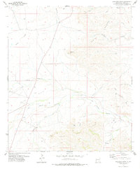
1978 Map of Bandanna Point
USGS Topo · Published 1978About this map
Azotea Mesa and the prominent landmark of Bandanna Point define this corner of the Chihuahuan Desert in the late 1970s. The landscape is etched by a complex network of ephemeral drainages, including Last Chance Canyon, China Canyon, and Sacahuiste Draw, which reveal the rugged hydrology of the region. This survey, compiled from 1972 aerial photography and 1974 field checks, serves as a record of resource extraction and ranching infrastructure in Eddy County. Scattered wells and stations such as Pipkin Well, Weldy Well, and Wagontire indicate the reliance on groundwater in this arid environment. Strategic natural features like the Sotol Basin and the Hess Hills provide topographic context for the numerous drill holes and gas wells that mark the era's energy exploration activities alongside older family-named sites like Lower John Well.
Find a feature on this map
28 named features on this map. Tap any name to fly to it.
Don’t see what you’re looking for? This feature index may not catch every label — zoom into the map to look around manually.
Map Details
Editions of this 1978 Bandanna Point Map
This is the sole edition of this map. No revisions or reprints were ever made.
Other maps of this area

1940 · Bandanna Point
USGS Topo · 1:62,500

1940 · Carlsbad Caverns West
USGS Topo · 1:62,500

1943 · Carlsbad Caverns West
USGS Topo · 1:62,500

1943 · Bandanna Point
USGS Topo · 1:62,500

1943 · West Carlsbad
USGS Topo · 1:62,500

1945 · West Carlsbad
USGS Topo · 1:62,500

1945 · Carlsbad Caverns East
USGS Topo · 1:62,500

1947 · Carlsbad Caverns East
USGS Topo · 1:62,500

1954 · Carlsbad
USGS Topo · 1:250,000

1958 · Carlsbad
USGS Topo · 1:250,000