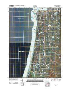
2011 Map of Bandon
USGS Topo · Published 2011About this map
The Coquille River Lighthouse stands at the northern edge of this coastal landscape, guarding the mouth of the Coquille River where it meets the Pacific Ocean. This 2011 survey of Bandon and its surroundings reveals a community deeply integrated with its maritime and creek-fed geography. Along the shoreline, sea stacks and landmarks like Face Rock, Haystack Rock, and the Devils Kitchen define the coastline south of Coquille Point. Further inland, the map captures the transition from the town center to rural settlements and agricultural corners such as Cranberry Corners, Dew Valley, and Laurel Grove. The infrastructure of the era is well-documented, from the Bandon State Airport and the Bandon Post Office to the Knights of Pythias Cemetery. Water management and industry are evident through features like the Dahl Log Pond, Bandon Reservoir, and the complex drainage of China Creek and Twomile Creek, which flow toward the New River.
Find a feature on this map
85 named features on this map. Tap any name to fly to it.
Don’t see what you’re looking for? This feature index may not catch every label — zoom into the map to look around manually.
Map Details
Editions of this 2011 Bandon Map
This is the sole edition of this map. No revisions or reprints were ever made.
Other maps of this area

1896 · Coos Bay
USGS Topo · 1:125,000

1898 · Coos Bay
USGS Topo · 1:125,000

1899 · Port Orford
USGS Topo · 1:125,000

1900 · Coos Bay
USGS Topo · 1:125,000

1903 · Port Orford
USGS Topo · 1:125,000

1943 · Bandon
USGS Topo · 1:62,500

1944 · Bandon
USGS Topo · 1:62,500

1954 · Coos Bay
USGS Topo · 1:250,000

1954 · Cape Blanco
USGS Topo · 1:62,500

1954 · Langlois
USGS Topo · 1:62,500