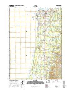
2017 Map of Bandon
USGS Topo · Published 2017About this map
The Coquille River meets the Pacific Ocean at Bandon, where a collection of dramatic coastal landforms like Face Rock, Sisters Rock, and Table Rock define the shoreline. This 2017 survey shows the coastal settlement’s layout alongside inland resource management features, including the Bandon Reservoir, Ferry Reservoir, and Dahl Log Pond. The landscape transitions from the urban grid of Bandon and the Bandon State Airport into the rural valleys of the south. Scattered communities and historic landmarks such as Dew Valley, Laurel Grove, and the Knights of Pythias Cem are connected by a network of creeks, including Twomile Creek and Fourmile Creek. The southern reaches of the map track the New River as it runs parallel to the coast, separated from the ocean by a narrow strip of land.
Find a feature on this map
81 named features on this map. Tap any name to fly to it.
Don’t see what you’re looking for? This feature index may not catch every label — zoom into the map to look around manually.
Map Details
Editions of this 2017 Bandon Map
This is the sole edition of this map. No revisions or reprints were ever made.
Other maps of this area

1896 · Coos Bay
USGS Topo · 1:125,000

1898 · Coos Bay
USGS Topo · 1:125,000

1899 · Port Orford
USGS Topo · 1:125,000

1900 · Coos Bay
USGS Topo · 1:125,000

1903 · Port Orford
USGS Topo · 1:125,000

1943 · Bandon
USGS Topo · 1:62,500

1944 · Bandon
USGS Topo · 1:62,500

1954 · Coos Bay
USGS Topo · 1:250,000

1954 · Cape Blanco
USGS Topo · 1:62,500

1954 · Langlois
USGS Topo · 1:62,500