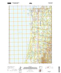
2020 Map of Bandon
USGS Topo · Published 2020About this map
Bandon sits at the mouth of the Coquille River, where the rugged Oregon coastline meets the Pacific. This 2020 survey illustrates the town's grid and its relationship with the prominent offshore sea stacks, including Face Rock, Haystack Rock, and the cluster known as Cat and Kittens Rock. The map details the transition from the coastal bluffs at Coquille Point to the agricultural and timbered lands further inland.
Find a feature on this map
92 named features on this map. Tap any name to fly to it.
Don’t see what you’re looking for? This feature index may not catch every label — zoom into the map to look around manually.
Map Details
Editions of this 2020 Bandon Map
This is the sole edition of this map. No revisions or reprints were ever made.
Other maps of this area

1896 · Coos Bay
USGS Topo · 1:125,000

1898 · Coos Bay
USGS Topo · 1:125,000

1899 · Port Orford
USGS Topo · 1:125,000

1900 · Coos Bay
USGS Topo · 1:125,000

1903 · Port Orford
USGS Topo · 1:125,000

1943 · Bandon
USGS Topo · 1:62,500

1944 · Bandon
USGS Topo · 1:62,500

1954 · Coos Bay
USGS Topo · 1:250,000

1954 · Cape Blanco
USGS Topo · 1:62,500

1954 · Langlois
USGS Topo · 1:62,500