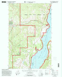
1992 Map of Bangs Mountain
USGS Topo · Published 1996About this map
Franklin D Roosevelt Lake Recreation Area dominates the eastern edge of this landscape, marking the impounded waters of the Columbia River as it forms the boundary between Ferry and Stevens Counties. The rugged interior is largely defined by the Colville National Forest, featuring the prominent heights of Bangs Mountain and the steep terrain of Donaldson Draw. Toward the north, the Sherman Creek Wildlife Recreation Area covers a large territory, with Sherman Creek winding through the valley toward Sherman Creek Point. Local infrastructure is represented by the historically evocative Flume Road, while smaller water features like Mud Lake, Lake Ellen, and several springs including Bens Spring dot the higher elevations. A lone Cem (cemetery) located near the center of the sheet provides a rare point of interest for genealogists tracing early settlement in this timbered region.
Find a feature on this map
22 named features on this map. Tap any name to fly to it.
Don’t see what you’re looking for? This feature index may not catch every label — zoom into the map to look around manually.
Map Details
Editions of this 1992 Bangs Mountain Map
This is the sole edition of this map. No revisions or reprints were ever made.
Other maps of this area

1936 · Marcus
USGS Topo · 1:96,000

1942 · Marcus
USGS Topo · 1:125,000

1948 · Sherman Peak
USGS Topo · 1:62,500

1948 · Kettle Falls
USGS Topo · 1:62,500

1950 · Inchelium
USGS Topo · 1:62,500

1951 · Sherman Peak
USGS Topo · 1:62,500

1951 · Kettle Falls
USGS Topo · 1:62,500

1952 · Twin Lakes
USGS Topo · 1:62,500

1954 · Okanogan
USGS Topo · 1:250,000

1958 · Okanogan
USGS Topo · 1:250,000