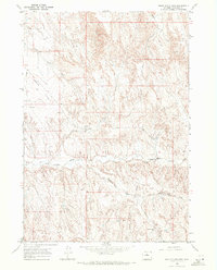
1966 Map of Banjo Flats East
USGS Topo · Published 1972About this map
Banjo Flats and the intricate drainage basins of the East Fork Nowater Creek characterize this high-desert landscape in Washakie County. Mapped in the mid-1960s, the terrain is marked by a network of ephemeral watercourses including Denver Draw, Jake Draw, and Little Denver Draw, which carve deep contours into the plateau. The map captures the infrastructure of the era's energy exploration, detailing numerous sites such as the Roush Well No 2, a Flowing Well, and several other locations labeled simply as Oil Well. A prominent Pipeline and the Marconi Road provide the primary human-made landmarks across this sparsely populated region. These features, along with Little Slick Creek, illustrate the intersection of natural topography and industrial utility during a period of active resource development in the Wyoming interior.
Find a feature on this map
13 named features on this map. Tap any name to fly to it.
Don’t see what you’re looking for? This feature index may not catch every label — zoom into the map to look around manually.
Map Details
Editions of this 1966 Banjo Flats East Map
2 editions found
Other maps of this area

1955 · Sheridan
USGS Topo · 1:250,000

1955 · Arminto
USGS Topo · 1:250,000

1958 · Sheridan
USGS Topo · 1:250,000

1958 · Arminto
USGS Topo · 1:250,000

1962 · Sheridan
USGS Topo · 1:250,000

1962 · Arminto
USGS Topo · 1:250,000
1966 · Zimmerman Buttes
USGS Topo · 1:24,000
1966 · Banjo Flats West
USGS Topo · 1:24,000

1966 · Cabin Fork
USGS Topo · 1:24,000

1966 · Wagon Prong
USGS Topo · 1:24,000