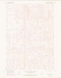
1966 Map of Banjo Flats East
USGS Topo · Published 1978About this map
Banjo Flats serves as the central landform of this Washakie County landscape, characterized by a complex network of drainage draws and resource extraction sites in the mid-1960s. The terrain is marked by intermittent watercourses like Little Slick Creek in the northwest and the winding path of the East Fork Nowater Creek further south. This survey captures a moment of active energy exploration across the high plains, evidenced by numerous infrastructure labels including an Oil Well, a Drill Hole, and a Flowing Well concentrated near the center of the sheet. Transportation is limited to rugged tracks such as Marconi Road, which skirts the eastern ridges. To the southeast, the geography transitions into the curiously named Little Denver Jake Draw, while the isolated Roush Well No 2 stands at the southern extent, illustrating the wide distribution of industrial activity across this sparsely populated region.
Find a feature on this map
9 named features on this map. Tap any name to fly to it.
Don’t see what you’re looking for? This feature index may not catch every label — zoom into the map to look around manually.
Map Details
Editions of this 1966 Banjo Flats East Map
2 editions found
Other maps of this area

1955 · Sheridan
USGS Topo · 1:250,000

1955 · Arminto
USGS Topo · 1:250,000

1958 · Sheridan
USGS Topo · 1:250,000

1958 · Arminto
USGS Topo · 1:250,000

1962 · Sheridan
USGS Topo · 1:250,000

1962 · Arminto
USGS Topo · 1:250,000
1966 · Zimmerman Buttes
USGS Topo · 1:24,000
1966 · Banjo Flats West
USGS Topo · 1:24,000

1966 · Cabin Fork
USGS Topo · 1:24,000

1966 · Wagon Prong
USGS Topo · 1:24,000