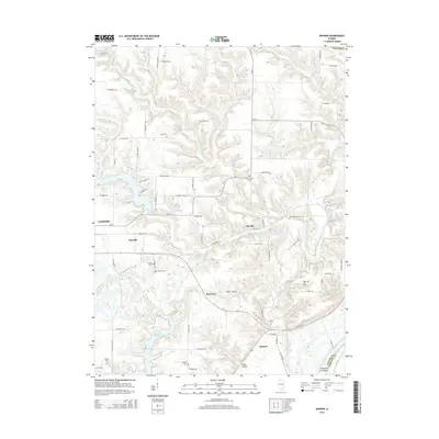
2015 Map of Banner
USGS Topo · Published 2015About this map
Banner and the surrounding river bottoms of Fulton County appear here in 2015, defined by the intricate drainage of Copperas Creek and its many branches. The landscape is dotted with small historical settlements such as Monterey, Breeds, and Rawalts, many of which grew around early rail lines and agricultural junctions. This survey is particularly valuable for genealogists, as it meticulously identifies numerous small burial grounds including Wolf Cemetery, Orendorff Cemetery, and Kings Hill Cemetery, which are often the only remaining markers of the area's earliest family farmsteads. Near the southern boundary, the Duck Creek Cooling Pond and Sturgeon Island illustrate the modified hydrology of the Illinois River floodplain. The network of rural roads, including Orion School Road and Cemetery Road, traces the path of early school districts and community centers that once served this rural landscape.
Find a feature on this map
76 named features on this map. Tap any name to fly to it.
Don’t see what you’re looking for? This feature index may not catch every label — zoom into the map to look around manually.
Map Details
Editions of this 2015 Banner Map
This is the sole edition of this map. No revisions or reprints were ever made.
Other maps of this area

1912 · Canton
USGS Topo · 1:62,500

1925 · Havana
USGS Topo · 1:62,500

1929 · Manito
USGS Topo · 1:62,500

1930 · Glasford
USGS Topo · 1:62,500

1932 · Manito
USGS Topo · 1:62,500

1947 · St. David
USGS Topo · 1:24,000

1948 · St. David
USGS Topo · 1:24,000

1948 · Glasford
USGS Topo · 1:62,500
1949 · Havana
USGS Topo · 1:62,500

1958 · Burlington
USGS Topo · 1:250,000