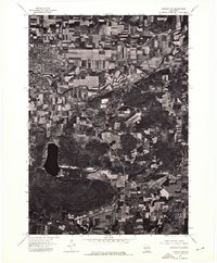
1974 Map of Baraboo NW
USGS Topo · Published 1976About this map
Baraboo and its surrounding rural landscapes are captured here in high-contrast aerial detail from a 1974 orthophotoquad. The imagery provides a clear view of the town's grid and the meandering path of the Baraboo River as it cuts through the valley floor. To the south, the deep, dark basin of Devils Lake is framed by the heavy forestation of the surrounding quartzite bluffs, creating a sharp visual contrast between the water and the complex textures of the woodland and agricultural fields. This mid-1970s perspective shows the transition from the concentrated urban core of the county seat into the expansive patchwork of southern Wisconsin farmland, documenting the era's land use patterns and forest cover before decades of later development changed the local footprint.
Find a feature on this map
3 named features on this map. Tap any name to fly to it.
Don’t see what you’re looking for? This feature index may not catch every label — zoom into the map to look around manually.
Map Details
Editions of this 1974 Baraboo NW Map
This is the sole edition of this map. No revisions or reprints were ever made.
Other maps of this area

1895 · Baraboo
USGS Topo · 1:62,500

1901 · Denzer
USGS Topo · 1:62,500

1901 · The Dells
USGS Topo · 1:62,500

1902 · Briggsville
USGS Topo · 1:62,500

1908 · Baraboo
USGS Topo · 1:62,500

1957 · Wisconsin Dells
USGS Topo · 1:62,500

1957 · Madison
USGS Topo · 1:250,000

1958 · Briggsville
USGS Topo · 1:62,500

1958 · North Freedom
USGS Topo · 1:62,500

1959 · Baraboo
USGS Topo · 1:62,500