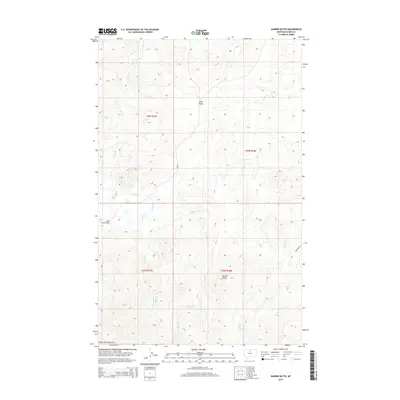
2014 Map of Barber Butte
USGS Topo · Published 2014About this map
Barber Butte stands as a prominent landmark in this northern Montana landscape, situated near the northern edge of the Bears Paw Mountains. The terrain is defined by the high elevations of Tiger Ridge and a series of deeply incised drainage systems, including Clear Cr, Wind Cr, and Grindstone Cr. This 2014 survey documents the remote character of southern Blaine County, where human infrastructure is limited primarily to section-line access roads like Wind Creek Ln and the Clear Creek Bridge. The map captures the complex topography of the region, illustrating the transition from the rugged mountain foothills to the high plains, providing essential detail for understanding the hydrological patterns and land divisions within the historic township and range system.
Find a feature on this map
14 named features on this map. Tap any name to fly to it.
Don’t see what you’re looking for? This feature index may not catch every label — zoom into the map to look around manually.
Map Details
Editions of this 2014 Barber Butte Map
This is the sole edition of this map. No revisions or reprints were ever made.
Other maps of this area

1953 · Havre
USGS Topo · 1:250,000

1956 · Maddux
USGS Topo · 1:62,500

1956 · Lloyd
USGS Topo · 1:62,500

1957 · Havre
USGS Topo · 1:250,000

1958 · Havre
USGS Topo · 1:250,000

1959 · Warrick
USGS Topo · 1:62,500

1959 · Shambo
USGS Topo · 1:62,500
1984 · Shambo NE
USGS Topo · 1:24,000

1984 · Big John Butte
USGS Topo · 1:24,000
1984 · Shambo SE
USGS Topo · 1:24,000