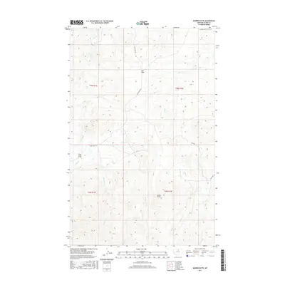
2017 Map of Barber Butte
USGS Topo · Published 2017About this map
Barber Butte and Tiger Ridge dominate this section of the Bear Paw Mountains in northern Montana, where high-elevation drainage patterns define the local geography. The area is characterized by a network of seasonal and perennial waterways including Grindstone Cr, Wind Cr, and Bean Cr, which carve through the varied terrain of the T29N and T30N townships. A notable human-made landmark is the Clear Creek Bridge, which provides passage over Clear Cr in the western portion of the map. Access throughout this rangeland is provided by a series of rural routes such as Clear Creek Rd, Lloyd Rd, and Hofeldt Tiger Ridge Rd Pvt, reflecting the area's continued use for grazing and ranching into the 21st century. The map provides a clear view of the topographic contours and the intersection of section lines that have governed land ownership and management in Blaine County for generations.
Find a feature on this map
16 named features on this map. Tap any name to fly to it.
Don’t see what you’re looking for? This feature index may not catch every label — zoom into the map to look around manually.
Map Details
Editions of this 2017 Barber Butte Map
This is the sole edition of this map. No revisions or reprints were ever made.
Other maps of this area

1953 · Havre
USGS Topo · 1:250,000

1956 · Maddux
USGS Topo · 1:62,500

1956 · Lloyd
USGS Topo · 1:62,500

1957 · Havre
USGS Topo · 1:250,000

1958 · Havre
USGS Topo · 1:250,000

1959 · Warrick
USGS Topo · 1:62,500

1959 · Shambo
USGS Topo · 1:62,500
1984 · Shambo NE
USGS Topo · 1:24,000

1984 · Big John Butte
USGS Topo · 1:24,000
1984 · Shambo SE
USGS Topo · 1:24,000