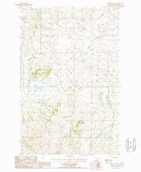
1987 Map of Barber Butte
USGS Topo · Published 1987About this map
Bearpaw Mountains dominate the southern landscape of this Blaine County region, rising sharply above the drainage basins of the north. The terrain is defined by the prominent Tiger Ridge and the distinct peak of Barber Butte, which serves as a central landmark for the area. The local hydrology is characterized by numerous seasonal and perennial flows, including Clear Creek, Wind Creek, and Bean Creek, which carve deep paths through the high plains. Human presence in this Montana landscape is marked by the infrastructure of ranching and industry, with several Corrals scattered throughout the valleys and a high-altitude Pipeline traversing the northern ridges. A Landing Strip situated near Wind Creek suggests the necessity of aerial access in this isolated territory during the late 1980s.
Find a feature on this map
14 named features on this map. Tap any name to fly to it.
Don’t see what you’re looking for? This feature index may not catch every label — zoom into the map to look around manually.
Map Details
Editions of this 1987 Barber Butte Map
This is the sole edition of this map. No revisions or reprints were ever made.
Other maps of this area

1953 · Havre
USGS Topo · 1:250,000

1956 · Maddux
USGS Topo · 1:62,500

1956 · Lloyd
USGS Topo · 1:62,500

1957 · Havre
USGS Topo · 1:250,000

1958 · Havre
USGS Topo · 1:250,000

1959 · Warrick
USGS Topo · 1:62,500

1959 · Shambo
USGS Topo · 1:62,500
1984 · Shambo NE
USGS Topo · 1:24,000

1984 · Big John Butte
USGS Topo · 1:24,000
1984 · Shambo SE
USGS Topo · 1:24,000