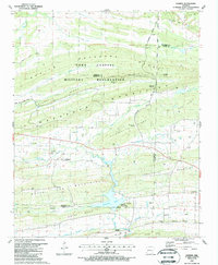
1987 Map of Barber
USGS Topo · Published 1988About this map
The Fort Chaffee Military Reservation dominates the northern landscape of this survey, marked by its boundary with the Franklin Co Sebastian Co line. The terrain is defined by a series of parallel ridges, including Devils Backbone and Washburn Mountain, which direct the flow of local waters like Big Creek and Washburn Creek. This late-1980s landscape shows a mix of rural infrastructure and natural resource extraction, evidenced by numerous gas wells and a Shale Pit scattered across the valley floors.
Find a feature on this map
54 named features on this map. Tap any name to fly to it.
Don’t see what you’re looking for? This feature index may not catch every label — zoom into the map to look around manually.
Map Details
Editions of this 1987 Barber Map
This is the sole edition of this map. No revisions or reprints were ever made.
Other maps of this area

1887 · Magazine Mountain #2
USGS Topo · 1:62,500

1887 · Magazine Mountain #3
USGS Topo · 1:62,500

1887 · Magazine Mountain
USGS Topo · 1:62,500

1890 · Magazine Mountain
USGS Topo · 1:125,000

1890 · Fort Smith
USGS Topo · 1:125,000

1906 · Lavaca
USGS Topo · 1:62,500

1906 · Barber
USGS Topo · 1:62,500

1934 · Booneville
USGS Topo · 1:48,000

1939 · Booneville
USGS Topo · 1:62,500

1943 · Fort Smith
USGS Topo · 1:125,000