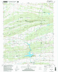
1997 Map of Barber
USGS Topo · Published 1999About this map
Fort Chaffee Military Reservation dominates the northern landscape of this Sebastian County quadrangle, where ridges like Backbone Mountain and Pinnacle Mountain run parallel across the terrain. This late-twentieth-century survey documents a region defined by its narrow valleys and natural gaps, such as Molly Gap, which provide passage through the ridges. To the south, the waters of Booneville Lake are supported by infrastructure including an Intake and Pumping Station. The map captures the small settlements of Barber and Glendale, along with evidence of former transportation networks like the Old Railroad Grade. Genealogists will find significant value in the scattered burial grounds, including Washburn Cem, Bell Cem, and the family-named Rebecca Lewis Cemetery, reflecting the rural heritage of the borderlands between Franklin, Logan, and Sebastian counties.
Find a feature on this map
50 named features on this map. Tap any name to fly to it.
Don’t see what you’re looking for? This feature index may not catch every label — zoom into the map to look around manually.
Map Details
Editions of this 1997 Barber Map
This is the sole edition of this map. No revisions or reprints were ever made.
Other maps of this area

1887 · Magazine Mountain #2
USGS Topo · 1:62,500

1887 · Magazine Mountain #3
USGS Topo · 1:62,500

1887 · Magazine Mountain
USGS Topo · 1:62,500

1890 · Magazine Mountain
USGS Topo · 1:125,000

1890 · Fort Smith
USGS Topo · 1:125,000

1906 · Lavaca
USGS Topo · 1:62,500

1906 · Barber
USGS Topo · 1:62,500

1934 · Booneville
USGS Topo · 1:48,000

1939 · Booneville
USGS Topo · 1:62,500

1943 · Fort Smith
USGS Topo · 1:125,000