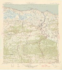
1946 Map of Barceloneta
USGS Topo · Published 1946About this map
The coastal industrial and agricultural landscapes of northern Puerto Rico are defined by the sugar economy in this mid-1940s survey. Large-scale operations like Central Plazuela and Central Monserrate dominate the lowlands, connected by the extensive tracks of the American Railroad of Puerto Rico. The map illustrates a transitional period where industrial sugar production and maritime transport converged at the mouths of the Río Grande de Manatí and Caño Tiburones.
Find a feature on this map
40 named features on this map. Tap any name to fly to it.
Don’t see what you’re looking for? This feature index may not catch every label — zoom into the map to look around manually.
Map Details
Editions of this 1946 Barceloneta Map
3 editions found
Other maps of this area

1942 · Manati
USGS Topo · 1:30,000

1942 · Arecibo
USGS Topo · 1:30,000

1942 · Barceloneta
USGS Topo · 1:30,000

1943 · Utuado NE
USGS Topo · 1:10,000

1946 · Barceloneta
USGS Topo · 1:30,000

1946 · Utuado
USGS Topo · 1:30,000

1946 · Ciales
USGS Topo · 1:30,000

1946 · Arecibo
USGS Topo · 1:30,000

1946 · Florida
USGS Topo · 1:30,000

1946 · Manati
USGS Topo · 1:30,000
Featured Places
- Barceloneta
- Sector Cerro Morales, Barceloneta
- Parcelas Boca, Barceloneta
- Parcelas Loarte, Barceloneta
- Punta Palmas, Barceloneta