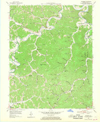
1954 Map of Barcreek
USGS Topo · Published 1968About this map
Town Mountain dominates the center of this Kentucky landscape, which was meticulously surveyed in the mid-1950s. The topography is defined by the winding course of the Goose River and its numerous tributaries, including Laurel Creek and Beech Creek. These waterways dictate the placement of small rural communities and institutions that once served local families. Schools are particularly prominent throughout the hills, from Antepast Sch in the north to the Upper Hector Sch in the south, reflecting a distributed network of early educational centers.
Find a feature on this map
98 named features on this map. Tap any name to fly to it.
Don’t see what you’re looking for? This feature index may not catch every label — zoom into the map to look around manually.
Map Details
Editions of this 1954 Barcreek Map
2 editions found
Other maps of this area

1891 · Manchester
USGS Topo · 1:125,000

1952 · Hima
USGS Topo · 1:24,000

1952 · Manchester
USGS Topo · 1:24,000

1953 · Oneida
USGS Topo · 1:24,000

1953 · Big Creek
USGS Topo · 1:24,000

1953 · Mistletoe
USGS Topo · 1:24,000

1954 · Barcreek
USGS Topo · 1:24,000

1954 · Maulden
USGS Topo · 1:24,000
1954 · Ogle
USGS Topo · 1:24,000
1954 · Creekville
USGS Topo · 1:24,000