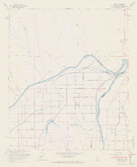
1965 Map of Bard
USGS Topo · Published 1966About this map
The Fort Yuma Indian Reservation dominates this desert landscape where the Colorado River and Gila River converge. By the mid-1960s, the region's agricultural character was firmly established through a complex network of irrigation, including the massive All American Canal and the Main Canal. The settlement of Bard serves as a central hub for the surrounding fields, while the nearby Potholes (Site) and its associated Potholes Cem indicate the location of earlier habitation near the river's edge. This map provides a detailed look at the transition from the arid uplands of Mission Wash and the Three C Mine to the lush, engineered environment of the Gila Valley. To the south, The Island is bounded by the Haughtelin Lake and Bard Lake oxbows, illustrating how the river's historical path shaped land use and school placement at the San Pasqual Valley Sch.
Find a feature on this map
39 named features on this map. Tap any name to fly to it.
Don’t see what you’re looking for? This feature index may not catch every label — zoom into the map to look around manually.
Map Details
Editions of this 1965 Bard Map
5 editions found

Other maps of this area

1903 · Yuma
USGS Topo · 1:125,000

1905 · Yuma
USGS Topo · 1:125,000

1926 · Fortuna
USGS Topo · 1:62,500

1929 · Fortuna
USGS Topo · 1:62,500

1929 · Laguna
USGS Topo · 1:62,500

1940 · Yuma
USGS Topo · 1:62,500

1942 · Yuma
USGS Topo · 1:250,000

1943 · Laguna
USGS Topo · 1:62,500

1945 · Picacho Peak
USGS Topo · 1:62,500

1945 · Yuma
USGS Topo · 1:62,500