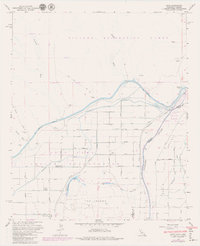
1965 Map of Bard
USGS Topo · Published 1979About this map
The Colorado River defines the border between California and Arizona on this survey, which captures the complex irrigation and desert landscape near the Gila River confluence. The Fort Yuma Indian Reservation occupies much of the terrain, where a rigid grid of streets from 2D Street up to 11th Street serves the small agricultural community of Bard. Vital water infrastructure is heavily documented, including the All American Canal, Main Canal, and Laguna Canal, which transformed this arid environment into productive land. To the north, the landscape shifts toward the Picacho Recreation Lands and the Yuma Proving Ground, where the Three C Mine and various prospects indicate the region's mineral history. Near the river, local landmarks like the Potholes Cem and Haughtelin Lake offer specific points of interest for genealogists and local historians studying this borderland.
Find a feature on this map
39 named features on this map. Tap any name to fly to it.
Don’t see what you’re looking for? This feature index may not catch every label — zoom into the map to look around manually.
Map Details
Editions of this 1965 Bard Map
5 editions found

Other maps of this area

1903 · Yuma
USGS Topo · 1:125,000

1905 · Yuma
USGS Topo · 1:125,000

1926 · Fortuna
USGS Topo · 1:62,500

1929 · Fortuna
USGS Topo · 1:62,500

1929 · Laguna
USGS Topo · 1:62,500

1940 · Yuma
USGS Topo · 1:62,500

1942 · Yuma
USGS Topo · 1:250,000

1943 · Laguna
USGS Topo · 1:62,500

1945 · Picacho Peak
USGS Topo · 1:62,500

1945 · Yuma
USGS Topo · 1:62,500