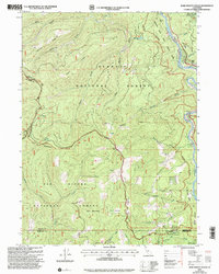
2001 Map of Bark Shanty Gulch
USGS Topo · Published 2004About this map
The Klamath Wild and Scenic River defines the eastern corridor of this terrain, where the R. Lyle Davis Bridge provides a critical crossing point near Young Ranch. This 2001 revision by the USDA Forest Service documents a landscape where the Klamath National Forest and Six Rivers National Forest converge at the borders of Siskiyou, Del Norte, and Humboldt counties. The map captures the specialized backcountry infrastructure of northern California, including isolated outposts like Beans Camp and Hines Camp. Ridge systems such as Lightning Ridge and Reynolds Ridge separate steep drainages like Bark Shanty Gulch and Beans Gulch. From the alpine waters of Ukononm Lake to the lower elevation Donahue Flat, the map details a region primarily used for timber management and river-based recreation at the start of the 21st century.
Find a feature on this map
36 named features on this map. Tap any name to fly to it.
Don’t see what you’re looking for? This feature index may not catch every label — zoom into the map to look around manually.
Map Details
Editions of this 2001 Bark Shanty Gulch Map
This is the sole edition of this map. No revisions or reprints were ever made.
Other maps of this area

1914 · Seiad
USGS Topo · 1:125,000

1922 · Preston Peak
USGS Topo · 1:125,000

1922 · Seiad
USGS Topo · 1:125,000

1925 · Hoopa
USGS Topo · 1:125,000

1948 · Weed
USGS Topo · 1:250,000

1950 · Weed
USGS Topo · 1:250,000

1952 · Orleans
USGS Topo · 1:62,500

1955 · Dillon Mtn
USGS Topo · 1:62,500

1955 · Ukonom Lake
USGS Topo · 1:62,500

1955 · Forks of Salmon
USGS Topo · 1:62,500